
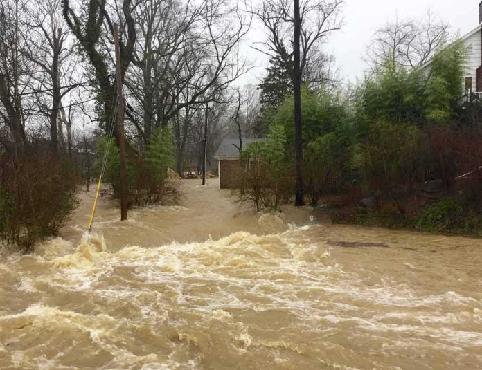
When a hurricane is downgraded, the danger often isn’t; in Hawaii, Lala’s shift to a tropical storm reduced its wind rating but not the hazards that actually harm people—torrential rain, flooding, surf, power loss, and debris-choked access.
The Short Version
- Lala weakened to a tropical storm but continued to deliver damaging hazards—heavy rain, strong winds, dangerous surf, and flooding—across multiple islands.
- Emergency managers emphasized that impacts would persist as the center passed the island chain, with hazards peaking differently by island and terrain.
- Warnings evolved by location as the storm translated west, but guidance remained consistent: avoid floodwaters, treat downed lines as live, and heed local orders.
- The episode illustrates a recurring truth in tropical weather risk: labels change quickly; water, access, and electrical risks persist.
What actually happened: a downgrade that did not end the danger
After a burst of hurricane-strength winds near Hawaii Island, Lala weakened to tropical-storm intensity as it moved along the island chain. The change in label did not neutralize its hazards. State emergency managers reported sustained tropical-storm winds with higher gusts and placed Lala’s center tens of miles southwest of Honolulu even as rain bands and wind maxima were still raking Oʻahu, Molokaʻi, and Kauaʻi. Officials warned of continuing threats: power outages, downed lines, contaminated floodwater, and washouts that would complicate rescue and recovery. In parallel, the Central Pacific Hurricane Center maintained tropical storm warnings for islands still in the wind and rain envelope; as the center progressed west, some warnings were pared back or discontinued while others remained in force, tracking the storm’s evolving footprint rather than the day’s top-line category label.
The practical picture on the ground fit that messaging. Gusts near hurricane force were recorded in wind-prone corridors and higher terrain, rainfall totals reached double digits with localized extremes, and surf on east and south exposures remained hazardous. Officials directed residents to stay off inundated roads, avoid driving into moving water, and operate generators outdoors far from living spaces. The emphasis was simple and repeated: storm intensity on a scale is not the same as risk to life and infrastructure; the latter lingers after the former weakens.
How tropical storms such as Lala inflict damage in Hawaii
The Hawaiian archipelago’s topography and exposure set the stage for water-driven impacts even when winds subside. Moist onshore flow forced up and over steep volcanic slopes wrings out extraordinary rainfall—an orographic effect that concentrates deluges on windward terrain and along mountain flanks. Those torrents run rapidly through narrow gulches, overtopping low-water crossings, undercutting road shoulders, and mobilizing rock and debris on saturated hillsides. In the coastal zone, long-period swell from a sprawling storm envelope focuses on certain exposures; even where wind speeds have eased, surf and setup can produce coastal flooding, beach erosion, and dangerous nearshore currents.
Wind still matters, particularly in saddles and ridgetops where channeling amplifies gusts; treefall and airborne debris sever distribution lines and block access routes. But for most households, what dictates harm is the compound problem of water and access: flood-contaminated interiors, shorted electrical systems, isolated neighborhoods, and an inability for responders to reach those who need help. That is why Hawaii’s emergency guidance during Lala stressed treating floodwater as hazardous, assuming every downed wire is live, and avoiding generator exhaust inside garages and lanais—post-storm fatalities often occur after the sky brightens, not during the peak gusts.
Why the warnings changed as the storm moved—and why that did not mean “all clear”
Federal and state warnings are hazard- and geography-specific. As Lala’s center migrated west-northwest, the wind and rain maxima shifted accordingly. The Central Pacific Hurricane Center issued, adjusted, and in some cases discontinued tropical storm warnings for counties where sustained winds abated; simultaneously, warnings remained or were initiated for islands still positioned to receive tropical-storm-force winds and heavy rain. This is not contradiction; it is the system working as intended, aligning official products with where hazards remain probable on the time horizon that matters for action.
For residents, the choreography can feel like mixed messages: a downgrade on one screen, a new or continuing warning on another. The correct interpretation is to track the hazard that applies to your location—wind, rain, surf, or flood—rather than seeking a single statewide “status.” Hawaii’s emergency managers and the National Weather Service offices have honed this approach across events because it reliably improves protective action: people respond to clear statements about what is coming to their neighborhood, when, and what to do about it.
Mechanics of risk communication: labels versus lived hazards
“Hurricane” and “tropical storm” are technical intensity bins based on one-minute sustained winds near the center; they are not impact scales. Water impacts—freshwater flooding from rain, coastal inundation from surge and swell—often scale with storm size, motion, moisture content, and topographic interaction more than with peak wind. Social-science work on warning effectiveness has, for years, urged communicators to lead with hazard, location, timing, and action—because people anchor on what affects them, not on abstract category labels. Messages that say “what to do” tied to “where and when” outperform those that only tell you “what it is”.
Hawaii’s emergency playbook reflects that research. During Lala, state updates prioritized concrete guidance—stay off flooded roads, keep generators outside, beware contaminated standing water—and kept the hazard framing current by island. This is not rhetorical nuance; it is a life-safety discipline learned across storms and tsunamis alike: concise, actionable warnings through trusted, redundant channels outperform generic advisories or label-driven headlines.
What the evolving products meant during Lala
For Big Island residents, the most punishing rains tapered earlier as the storm’s core moved west, but runoff, debris flows, and infrastructure damage persisted, necessitating patience in reentry and caution around compromised roadways and utility corridors. For Oʻahu and Kauaʻi, wind maxima and embedded rain bands arrived later, with warnings sustained to match those timing windows; airports, hospitals, and lifeline sectors shifted to contingency power where needed, and emergency operations centers synchronized status checks and resource requests accordingly. With the center sliding southwest of Honolulu and then south of Kauaʻi, the arc of strongest winds and squalls pivoted; accordingly, the National Weather Service and Central Pacific Hurricane Center discontinued some warnings, kept others, and messaged marine and surf hazards that lag the wind peak.
This pattern—east-to-west hazard progression across the chain—is routine in central Pacific cyclones. The operational implication is also routine: damage assessment and debris clearance begin in the relative calm behind the storm while response forces remain postured forward on islands still in the strike zone. The public sees both activities at once—cleanup in one county, new warnings in another—and may misread the juxtaposition. Understanding the sequence helps reconcile those images: the event is not “over” statewide simply because it has eased somewhere else.
How to think about next steps when the wind has eased but the risks have not
The transition from response to recovery is the riskiest phase for households. The impulse to check property can collide with unstable ground, live wires hidden in water, and carbon monoxide from indoor generator use. The National Hurricane Center’s standing guidance remains sound: return home only when authorities say it is safe; never drive through floodwater, which can hide roadbed failures; check on neighbors; and run any generator outdoors and well away from windows and doors. These instructions are not boilerplate—they are engineered against the most common, preventable post-storm injuries and deaths.
For communities, the arc is familiar. Utilities prioritize transmission corridors, then distribution; water and wastewater operators clear intakes and monitor contamination; public works triages slides and culvert failures; and emergency management sustains mass care for those displaced. In coastal zones, life-guarded beaches may remain red-flagged for days after skies clear because nearshore currents and surf remain treacherous. “Downgrade” does not govern any of that work; conditions on the ground do.
RESCUERS BECOMING THE RESCUED ON ARRIVAL 🚑🌊
Two Hawaii County paramedics responding to the chaos of Tropical Storm Lala on Saturday ended up having to scramble onto the roof of their own ambulance just to escape rising floodwaters.
Even the professionals taking the shift get…— Maria Mel (@Mariamelx58) August 17, 2026
The larger lesson: judge the storm you feel, not the label you hear
Across the tropics, the modern record’s deadliest impacts are overwhelmingly water-driven. In an island chain with steep terrain and limited redundancy in transportation corridors, Lala’s downgrade did nothing to erase the risks most people actually face. The warning enterprise—emergency proclamations, county alerts, forecast discussions, and briefings—works best when residents adopt the same lens: pay attention to the hazard for your place and time, and act on that guidance.
Sources:
youtube.com, dod.hawaii.gov, nhc.noaa.gov